North Bank Bridge Park
Reclaiming A Post-Industrial Riverfront
By John Amodeo and Cathy Offenberg
Photos: Chuck Choi
There are few things Greater Boston is more well-known for than the Charles River and the landmarks, parks, and trails that border it. Every year, thousands of families, runners, and cyclists enjoy these footpaths as they explore the historic city around them. But there is the “The Lost Half Mile,” a formerly inaccessible portion of the Charles River, officially known as the New Charles River Basin, that extends from Monsignor O’Brien Highway between the Museum of Science and Leverett Circle to the Charlestown Bridge.

Tasked by the Massachusetts Department of Transportation (DOT) and Massachusetts Department of Conservation & Recreation (DCR) to create the first river-edge connection between the Charles River and Boston Harbor, CRJA-IBI Group served as landscape architect and member of the Prime Consultant Joint Venture team of Ammann & Whitney (now The Louis Berger Group), Greenman-Pedersen, Inc., and Stantec (formerly Vollmer Associates), to reclaim “The Lost Half Mile.” The goal was to transform the derelict underbridge space and weave it back into the fabric of the New Charles River Basin park system, fulfilling Charles Elliot’s century-old vision for uninterrupted paths from the Esplanade to Boston Harbor.
The $26-million North Bank Bridge and its associated park component is the final park project in the New Charles River Basin, one that encompassed a complex public process, balancing the needs of several public agencies and numerous public constituents. The 11-acre park contains waterfront esplanades, passive open space, and special treatment to animate the underbridge pedestrian environment on both the Boston and Cambridge sides of the river.
The planning process included siting a maintenance facility and accommodating such active recreation facilities as multi-use trails, soccer fields, tennis courts, and a skateboard park, much of which will be added in future phases.
Underbridge Plaza And A New Paradigm
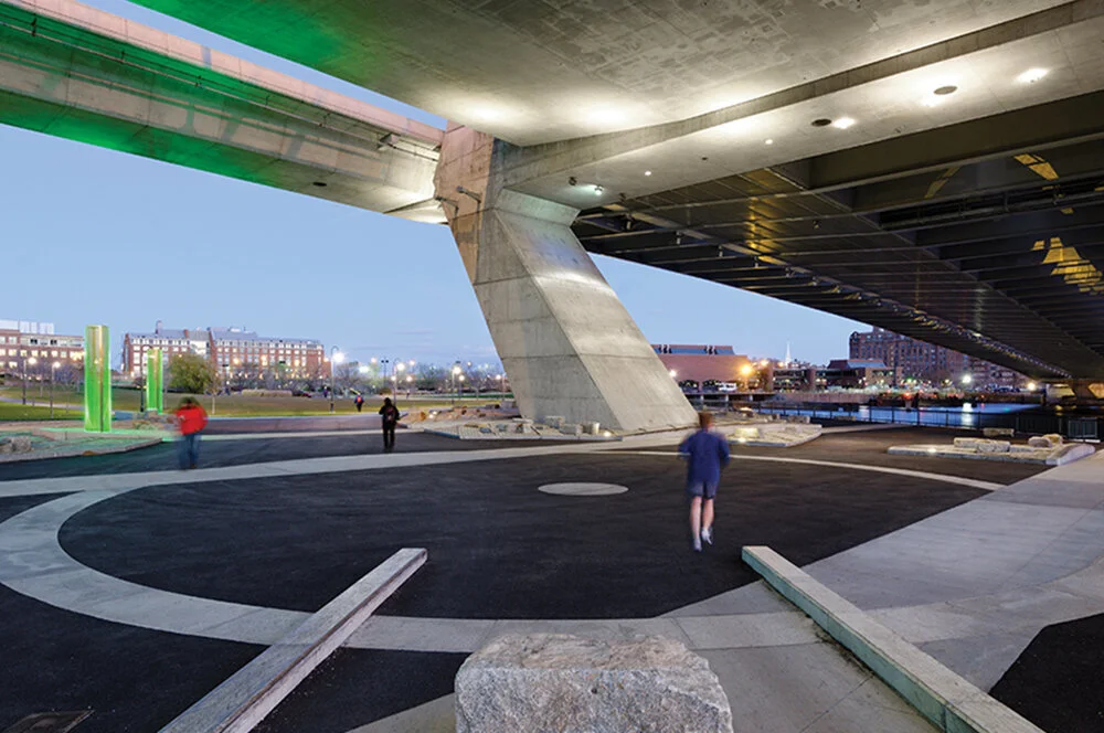
A key feature of the park is the Underbridge Plaza, an unexpected urban outdoor room that borders on the Charles River and uses the Zakim Bridge as its roof. CRJA-IBI Group saw an opportunity to create a new type of urban public space that responds directly to the extant urban-industrial setting and the sleek monumentality of the sculptural bridge and highway infrastructure. Though the firm’s approach challenged the initial direction provided by the client and the Citizens’ Advisory Committee, which was to move people through the space as quickly as possible, CRJA-IBI Group prevailed in promoting a memorable urban plaza beneath the Zakim Bridge. The uncluttered space allows for such unanticipated uses for dog walkers, joggers performing morning calisthenics using the low retaining walls, cycle clubs holding dance parties, people offering marriage proposals, and film shoots for luxury car ads, giving evidence to the fascination and appeal this space holds for the public.
Softscape Meets Hardscape
In the Underbridge Plaza, the paving design reflects linear folds in the underside of the Zakim Bridge. Landforms—which help to guide circulation—transition from soft to hard as they slip under the bridge. Subtle uplighting invites the public into the Underbridge Plaza, while also establishing clear sightlines into and through the plaza. To celebrate the verticality of the surrounding concrete highway piers, and to give a sense that “the lights were on,” CRJA-IBI Group conceived of vertical light pylons to “occupy” and animate the plaza, a concept implemented in collaboration with an artist. The colorful pylons frame the twisting sinusoidal North Bank Bridge, creating a dynamic composition of art and engineering.
The park landscape curvilinear geometry and the Underbridge Plaza linear geometry extend into one another, creating a cohesive and welcoming sequence to the waterfront, the underbridge environment, and to the North Bank Bridge beyond.
Armstrong Maples, placed along the multi-use path from Charlestown, celebrate the verticality of the Zakim Bridge Tower, inviting the public with familiar park vernacular to the Underbridge Plaza and the North Bank Bridge connection to Cambridge.
The lawn area to the east of the Zakim Bridge, called “The Knoll,” was designed as a high point from which one could enjoy views of and beneath the bridge, views of the Boston skyline to the south with the Charles River in the foreground, and a visual connection to the harbor over and beyond the massive Charles River Dam administration building, which sits on the dam. The Knoll was also the yin to the yang of adjacent Paul Revere Park’s oval event lawn. Unfortunately, due to the late discovery of a 96-inch diameter sewer pipe belonging to the Massachusetts Water Resources Authority, the height and volume of The Knoll had to be considerably reduced to avoid the weight of the proposed additional soil from compressing the subsurface organic layer that might potentially damage the existing pipe. The Knoll, as implemented, still serves as intended, even if done so with a more subtle presence.
Connections And An Icon
The North Bank Bridge, the project’s sculptural centerpiece, spans the Millers River, a commercial Duck Boat launch, and the MBTA Commuter Rails to form vital pedestrian and bicycle connections between neighboring Cambridge and Charlestown. It also creates a lively sculptural element within the park, an iconic piece of bridge architecture that complements, rather than competes with the even more iconic Zakim Bridge. CRJA-IBI Group worked with the bridge designer to develop the bridge’s reverse curved horizontal alignment to create a seamless interface with approaching park pathways, while offering a dramatic view centered on the bridge’s north pylon.
Sustainability
Part of reclaiming this urban waterfront entailed using rigorous sustainable measures, such as native plantings, to restore parts of the riverbank and form the east abutment of the North Bank Bridge, the reclaiming stone seawall blocks and granite cobblestones from other parts of the Central Artery project, and coordinating a complex brownfield-reclamation effort that consisted of the removal and capping of various on-site contaminated materials. Cobblestones and reclaimed seawall blocks extend the greensward landform into the underbridge environment. A leveling course beneath the guardrail and seawall capstone smooths out the horizontal and vertical variations in the existing seawall, enhancing the esplanade experience.
Connecting The Community
Since opening day, pedestrians, joggers, cyclists, and skaters have been streaming through this intermodal park like it’s always been there.
The planning and design for the North Bank Bridge Park, which took nearly a decade, was guided by the overriding conviction that the public would one day be thrilled to come into this new realm, to see the city from a new vantage point, and to appreciate the unique experience of being “up close” with the colossal Zakim Bridge structure.
The North Bank Bridge Park is an award-winning project, having earned the 2017 Excellence Award in Design from the Boston Society of Landscape Architects, as well as the World Architecture News 2017 Landscape Award.
John Amodeo, ASLA, LEED AP BD+C, and Cathy Offenberg, ASLA, are principals at CRJA-IBI Group, an award-winning landscape architectural design and environmental planning practice with offices in Boston and Knoxville. For more information, please visit http://crja.com.