An Intentional Collision
An intersectional approach to park planning
By Clement Lau
Have you heard of “intersectional planning” as it relates to parks and recreation? Essentially, the term refers to “the integration between planning for green spaces and for other elements, such as transportation, housing, and water management,” and is an approach that recognizes “parks and open space as closely connected with their neighborhoods and rely on community-driven plans to meet the diverse needs of stakeholders” (Jennings, et al. 2019). Intersectional planning makes sense because parks are not isolated spaces, and park planning cannot be done effectively or holistically without considering the social, economic, political, and physical context in which parks are located. For those of us who serve as park planners, we must think beyond park boundaries, see the big picture, and plan with interconnections in mind.

Figure 1: County plans.
Sources: Los Angeles County Departments of Parks and Recreation, Public Health, Public Works, Regional Planning, and Chief Sustainability Office
Big-Picture Thinking
So, how do we do this practically? Let’s take a look at the county of Los Angeles, for example. For starters, park-planning efforts focus on sustainability, are equity-based so the highest-need communities are prioritized, and consider parks as key infrastructure needed to maintain and improve the quality of life for all residents (see http://placeworks.com/wp-content/uploads/2017/11/SustainabilityPark_Lau_NovemberPlanning2017.pdf). Parks and recreation is also fully integrated into countywide planning documents like the General Plan, which includes a parks and recreation element and the recently adopted OurCounty Sustainability Plan that contains a major goal and strategies to improve park access.
In addition, it helps tremendously that the county has formed the Healthy Design Workgroup (http://www.publichealth.lacounty.gov/place/PLACE_Healthy_Design_Workgroup.htm), which is led by the Department of Public Health (DPH) and facilitates relationship-building, information-sharing, and collaboration and coordination on policies, plans, and projects among departments. Furthermore, the county has tools like the Department of Regional Planning (DRP)’s Equity Indicators Tool (http://planning.lacounty.gov/equity) and the Department of Parks and Recreation (DPR)’s Park Planning Viewer (see https://www.parksandrecbusiness.com/articles/2019/5/beyond-location-maps), which enable planners to view and analyze multiple sources and layers of data.
Case Study: West Athens-Westmont
To see how intersectional planning plays out in a local community, let’s focus on West Athens-Westmont. This unincorporated area has a population of about 41,000 residents and a high level of park need per the 2016 Countywide Parks Needs Assessment. It only has 0.2 acres of parkland per 1,000 residents, and just 26 percent of its residents are within walking distance (a half-mile) of a park; both figures are well below countywide averages. The community also has gang-related crime and safety issues that discourage residents from using parks and other public spaces.
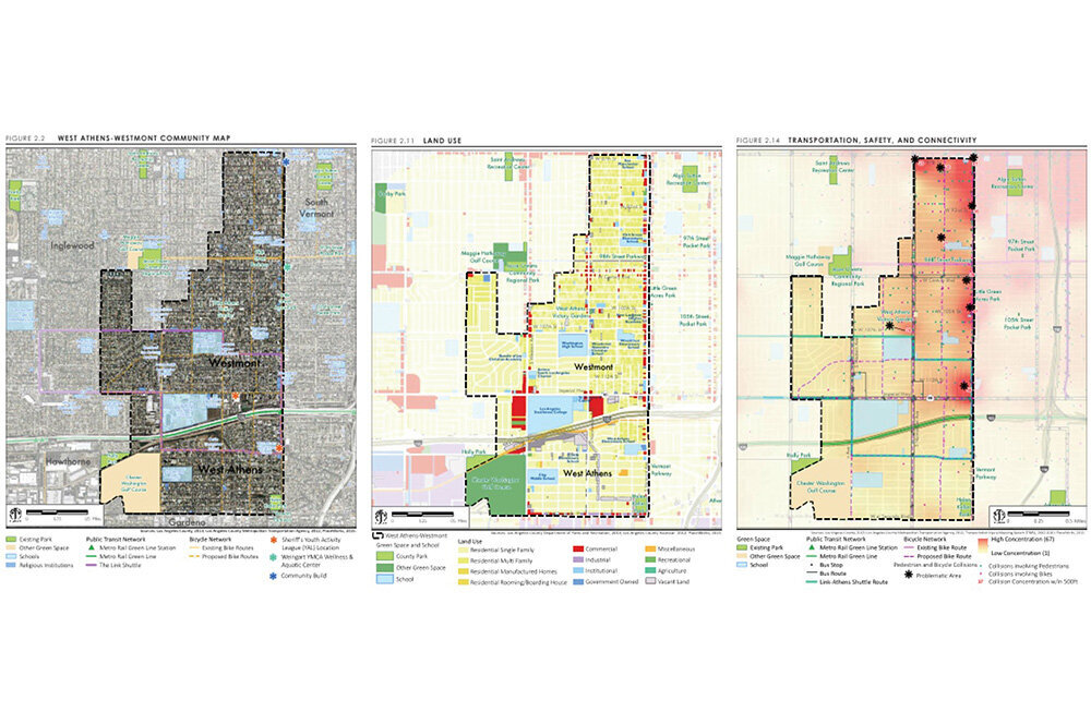
Figure 2: Maps from the West Athens-Westmont Community Parks and Recreation Plan.
Sources: Los Angeles County Department of Parks and Recreation; PlaceWorks
Recognizing the significant needs of the community, DPR completed a Community Parks and Recreation Plan (CPRP) in 2016, which provides a vision and roadmap to create a safer, greener community based upon public input and detailed analyses. In early 2019, DPR also received a 10-Minute Walk Planning Grant from the National Recreation and Park Association to develop a plan to specifically improve park access. This has provided an impetus for DPR to examine and address the intersections and interconnections between various planning efforts, as explained below.
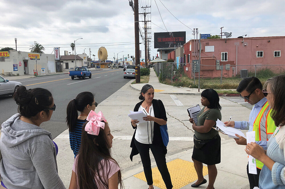
Figure 3: Community Walk participants on Normandie Avenue.
Source: Clement Lau, Los Angeles County Department of Parks and Recreation
Pedestrian Planning and Parks
Soon after the CPRP was completed, DPH embarked on a process to develop Step by Step LA County (http://www.publichealth.lacounty.gov/place/stepbystep/lacounty.htm), which provides a policy framework to get more people walking, make walking safer, and support healthy active lifestyles, and that includes Community Pedestrian Plans for four unincorporated communities, one of which is West Athens-Westmont. The Pedestrian Plan builds upon the findings and recommendations of the CPRP and includes actions and programs to improve pedestrian access to existing and planned parks.
One proposed program is a wayfinding system that helps pedestrians navigate major community-serving destinations, such as parks, transit stations, libraries, schools, and business districts. A wayfinding system can take various forms but typically includes a combination of physical signs, markers, and/or information kiosks. Another example is a Safe Passages program, which is designed to enhance safety for community members walking to schools and parks in communities with high violence or crime in order to ensure they can access resources, be physically active, and engage with neighbors.
The Department of Public Works (DPW) has partnered with DPH to develop the Vision Zero Action Plan (https://pw.lacounty.gov/visionzero/), which describes objectives and actions to eliminate traffic-related fatalities on unincorporated county roadways by 2035. An alarming finding from the plan is that five of the top 20 collision-concentration corridors in unincorporated areas are located in West Athens-Westmont. This reflects the high number of fatal and severe-injury collisions involving pedestrians and bicyclists in the community, and explains to some extent the high percentage (48 percent) of residents surveyed by DPR who do not feel safe walking to parks.
DPH, DPR, and DPW recently hosted a community walk to discuss planned park and pedestrian improvements along Normandie Avenue, one of the collision-concentration corridors. This event helped both residents and county staff members to experience firsthand the condition of roads and sidewalks connecting two future parks, discuss the proposed changes to enhance the pedestrian experience, and better understand the process and timeline for implementing various improvements.
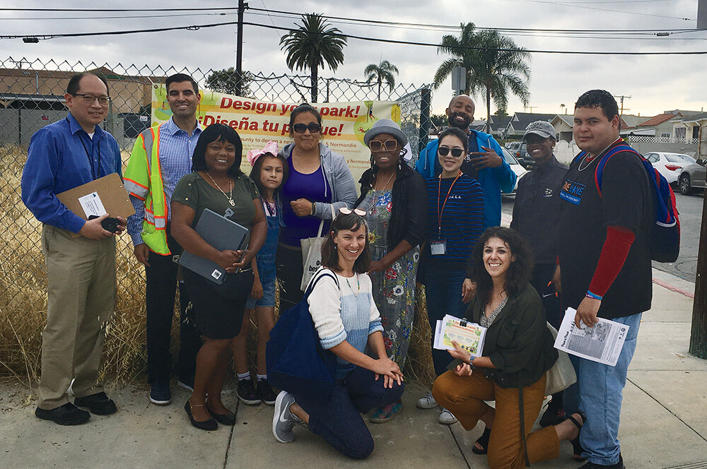
Figure 4: Community Walk participants at a future park site.
Source: Monica Carlos Tellalian, Los Angeles Neighborhood Initiative
Land-Use Planning And Parks
There is also a strong connection between land-use planning and parks. DRP has completed Connect Southwest LA (http://planning.lacounty.gov/southwest), which is the Transit-Oriented District (TOD) Specific Plan that lays the foundation to create a more walkable, transit-oriented area with a mix of land uses that is accessible by all modes of transportation, with an emphasis on transit, walking, and bicycling. The plan takes into consideration other plans developed for West Athens-Westmont, including the CPRP and the Pedestrian Plan, acknowledges the need for additional parks in the community, and establishes design guidelines on a range of issues, such as circulation and access, scale and massing of buildings, open space, street trees, and parking facilities.
Trauma Prevention and Parks
DPH partners with residents and stakeholders to implement the Trauma Prevention Initiative (TPI) (http://publichealth.lacounty.gov/ivpp/TPI.htm) to reduce violence-related injuries and deaths. Launched in 2015, TPI is initially focused on South Los Angeles, with West Athens-Westmont as one of the priority areas where there is ongoing community engagement that builds local leadership, promotes positive identity, and develops priorities to guide violence-prevention work through a Community Action for Peace (CAP) group, community events, and summits. As part of its 10-Minute Walk planning work, DPR staff participated in various TPI/CAP events to gather input on park access and safety issues, and provide updates on survey results and park projects.

Figure 5: Youth Summit in West Athens-Westmont.
Source: Patricia Hernandez, Los Angeles County Department of Public Health
Moving Forward
Better park planning involves breaking down silos. Park planners must adopt an intersectional planning approach which requires an understanding of the big picture and interconnections between parks and other quality-of-life issues. As demonstrated in the example above, park planning should be done in coordination and collaboration with the community, various county departments, and other partners. We need to look beyond the boundaries of a park and understand and address important factors like safety, land use, and transportation that affect how and whether residents travel to and use existing and future parks.
Reference
Jennings V, Browning M, Rigolon, A (2019) Urban Green Spaces: Public Health and Sustainability in the United States. Springer, Switzerland.
Clement Lau, AICP, DPPD, is a Departmental Facilities Planner with the Los Angeles County Department of Parks and Recreation. Reach him at clau@parks.lacounty.gov.